Alternatives for Further Study
Choose an alternative below:
- ALL
- EA
- F
- X
ALL
Last Chance Grade Alternatives for Further Study
The 2015 Last Chance Grade Feasibility Study identified a number of possible alternatives to the existing highway. Several alternatives were excluded from further study; the remaining alternatives were further analyzed and refined in the Project Study Report in 2016.
Since then, Caltrans has conducted preliminary geotechnical and environmental studies, a Geotechnical Expert-Based Risk Assessment, and a Value Analysis Study that resulted in seven alternatives. The Alternatives Analysis process, completed with stakeholder participation in April 2021, identified two alternatives that will be studied further in the Environmental Impact Report/Environmental Impact Statement (EIR/EIS) document. By directing resources to the better performing alternatives, Caltrans can reduce the time and resources spent on studies.
Use the buttons above to select an alternative and learn more about each of them.
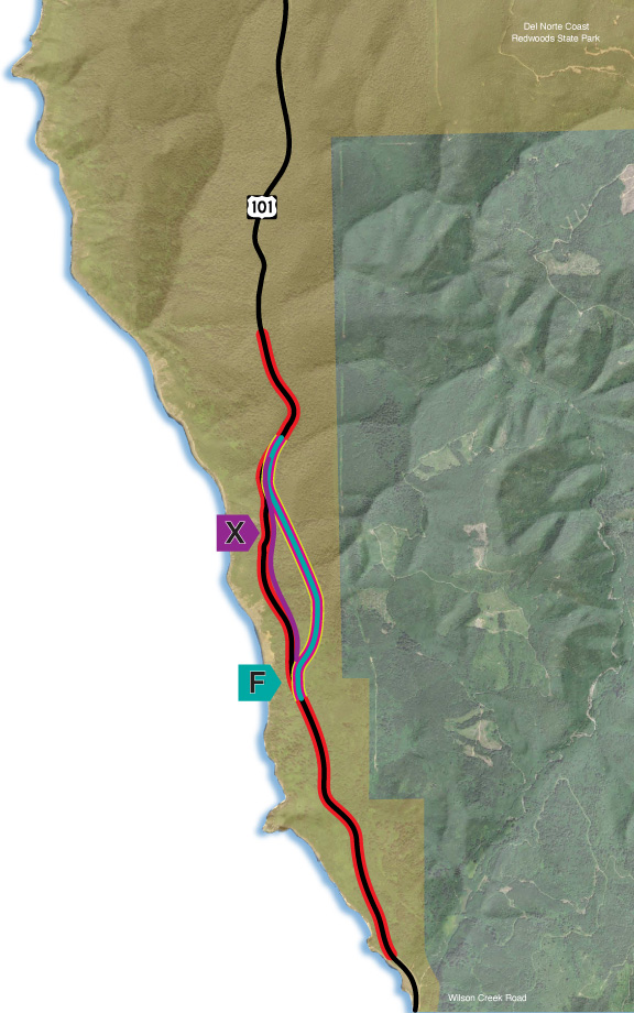
Each alternative is denoted with a letter, indicating one of the solid lines on the map.
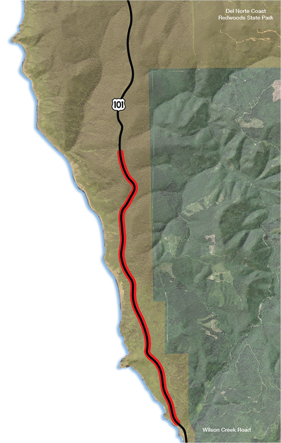
On the maps, the red line indicates the current LCG alignment; dark pink segments outlined in yellow indicate the approximate position of tunnels.
Click here to see the alternatives that have been eliminated from further study.
EA
Maintain Existing Alignment
This alternative would have no planned construction; US 101 would continue on its existing alignment. Regular maintenance and operations would continue, with emergency restoration projects as needed. Current annual maintenance costs $2 million with a projected cost of approximately $26 million by 2034. Engineering solutions, such as retaining walls, have not been able to provide long-term stability and will continue to be necessary to provide an adequate highway facility. As the landslide moves slowly, the road will require costly repairs and maintenance with potential environmental impacts including old-growth redwood impacts associated with minor retreats to keep the roadway open. A future slide might occur that is deep enough and large enough that it could result in a major failure of the roadway and complete closure of the roadway for an unknown period of time. A major failure would have economic impacts and require a significant detour as outlined in the Economic Impact Study. Some potential options closest to the existing alignment include a retreat upslope that could require taking more than 100 old-growth trees. For a more detailed explanation, please refer to page 15 of the Engineered Feasibility Study, available in the Document Library.
On the map, the red line indicates the current LCG alignment.
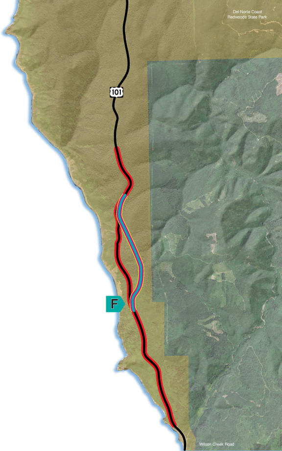
F
Tunnel Bypass
What is Alternative F?
Alternative F features a tunnel that avoids the landslide hazard and limits impacts to natural and cultural resources at the north and south portals. The proposed tunnel would be approximately 1 mile in length with one lane in each direction along with bike/pedestrian facilities. Some of the features would be similar to the Tom Lantos Tunnels at Devil’s Slide on Highway 1, south of Pacifica in San Mateo County, California.
Why Was Alternative F Selected for Further Study?
The tunnel would provide more stability and reliability by avoiding the landslides. The tunnel would pass deep under an area of significant natural and cultural resources, greatly reducing potential environmental impacts. Use of sequential excavation methods would reduce the construction impacts and the amount of soil to be hauled off-site. While the tunnel alternative is significantly higher in cost than Alternative X, it was not higher than the cost of other alternatives analyzed. It also would have the smallest environmental footprint of all alternatives studied to date, which would limit potential environmental resource impacts.
Key Project Features
Anticipated time to constuct: 6-8 years
Estimated cost to construct (year 2031 $): $2.1 billion
Associated Impacts to Key Resources
Permanent impacts to:
Redwood Forest: 0.64 acres
Sitka Spruce Forest: 0.20 acres
Red Alder Forest: 2.97 acres
Anticipated Large Trees Removed:
Douglas Fir: 9
Red Alder: 40
Coast Redwood: 39
Sitka Spruce: 49
Western Hemlock: 7
Total: 144
Permanent Impacts on Wetlands/Waters:
0.38 acres
On the map, the alternative is denoted with a letter. The red line indicates the current LCG alignment and the dark pink segment with yellow border indicates the approximate position of the tunnel.
Please note the following:
- The lines on the map are approximate and do not indicate the exact placement of the alternative.
- The acreages of “Existing Habitat Type” are estimates based on overall analyses of habitat types in the area.
- Costs are estimated and include construction, materials disposal, and mitigation.
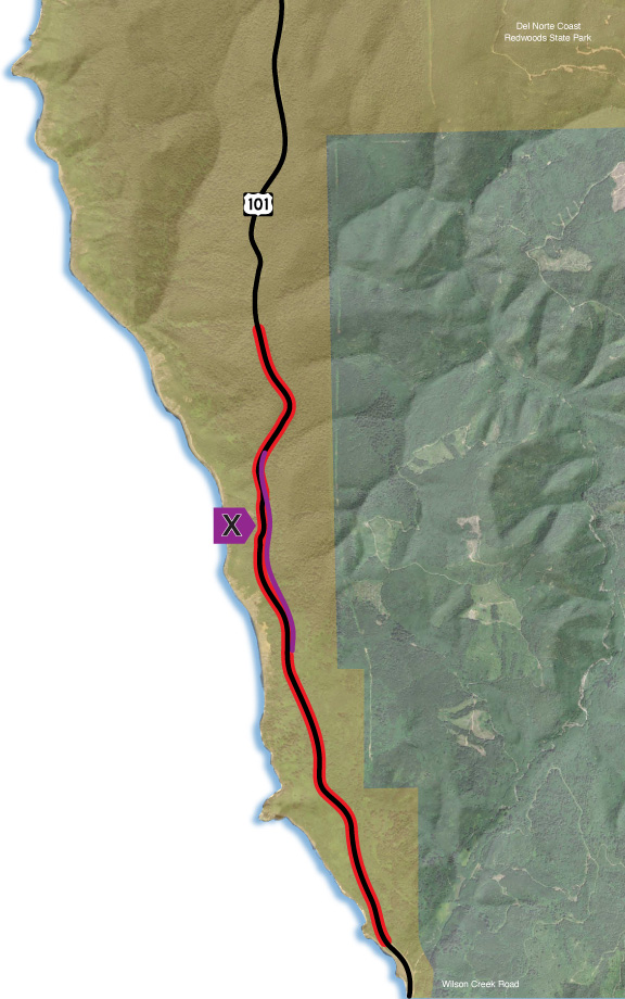
X
End-to-End Re-Engineering
What is Alternative X?
Alternative X is an holistically engineered end-to-end alternative that mitigates the landslide hazard along an alignment generally similar to that of the current highway. This design alternative would go far beyond what has been accomplished by the current and historic emergency repairs.
Alternative X would rely on proven engineering practices that have been implemented across the state. These would include:
- realignment retreat to the east at key locations;
- drainage infrastructure to minimize slope movement;
- tiered and steel-reinforced walls - above and below the new alignment; and
- regrading adjacent soil and rock slopes to flatter angles.
Why Was Alternative X Selected for Further Study?
Alternative X is currently the lowest cost alternative and would have the second smallest environmental footprint of all the alternatives studied to date, limiting potential environmental resource impacts. It also would have the shortest construction duration.
Key Project Features
Anticipated time to constuct: 3-5 years
Estimated cost to construct (year 2031 $): $880 million
Associated Impacts to Key Resources
Permanent impacts to:
Redwood Forest: 0.10 acres
Sitka Spruce Forest: 0.29 acres
Red Alder Forest: 1.57 acres
Anticipated Large Trees Removed:
Douglas Fir: 44
Red Alder: 13
Coast Redwood: 52
Sitka Spruce: 20
Western Hemlock: 0
Total: 129
Permanent Impacts on Wetlands/Waters:
0.03 acres
On the map, the alternative is denoted with a letter. The red line indicates the current LCG alignment.
Please note the following:
- The lines on the map are approximate and do not indicate the exact placement of the alternative.
- The acreages of “Existing Habitat Type” are estimates based on overall analyses of habitat types in the area.
- Costs are estimated and include construction, materials disposal, and mitigation.