Alternatives for Further Study
Choose an alternative below:
- ALL
- EA
- F
- X
ALL
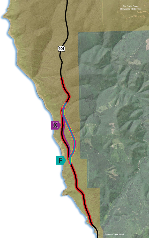
Last Chance Grade Alternatives for Further Study
The 2015 Last Chance Grade Feasibility Study identified numerous potential alternatives. Several alternatives were excluded from further study because analysis indicated they would have much greater potential impacts without adding any unique value. The remaining alternatives were further analyzed and refined in the Project Study Report in 2016.
Caltrans has since conducted preliminary geotechnical and environmental studies, a Geotechnical Expert-Based Risk Assessment, and a Value Analysis Study, resulting in seven alternatives. A series of Alternatives Analysis Workshops, involving stakeholder participation, was completed in April 2021. Based on the results of the Workshops, two alternatives were selected for further study. By focusing efforts on these alternatives, Caltrans has been able to reduce the time and resources needed for overall evaluation and for development of the Environmental Impact Report/ Environmental Impact Statement (EIR/EIS).
Use the buttons above to select an alternative and learn more about each of them.
Each alternative is denoted with a letter, indicating one of the solid lines on the map.
On the maps, the red line indicates the current LCG alignment; dark pink segments outlined in yellow indicate the approximate position of tunnels.
Click here to see the alternatives that have been eliminated from further study.
EA
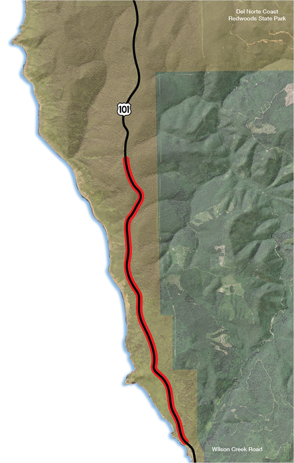
Maintain Existing Alignment
What is Alternative EA?
The existing alignment, or “No-Build” alternative, would include no planned construction; US 101 would remain on the existing alignment. Regular maintenance and operations would continue, and emergency repairs would be performed as needed. Current annual maintenance costs are approximately $3.5 million with a projected potential cost of $45.5 million by 2034.
Periodic repairs required to maintain the existing alignment are expected to continue resulting in impacts to traffic. Ongoing construction activities may result in environmental impacts, including impacts to sensitive park resources. A long-term closure of the highway would have economic impacts and require a significant detour as outlined in the Economic Impact Study. For a more detailed explanation, please refer to page 15 of the Engineered Feasibility Study, available in the Document Library.
On the map, the red line indicates the current LCG alignment.
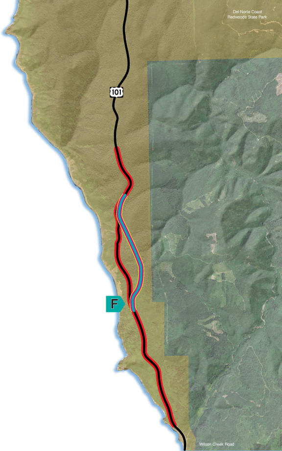
F
Tunnel Bypass
What is Alternative F?
Alternative F features an underground tunnel that avoids most of the landslide complex. It is anticipated that such a tunnel would provide a more reliable route compared to the existing highway. The proposed tunnel would be approximately one mile in length with one lane in each travel direction. The tunnel would have eight-foot shoulders and a separated bike/pedestrian facility. To support ongoing maintenance needs, Alternative F would also include an Operations and Maintenance Center.
Alternative F would include:
- Major realignment to the east;
- Approximately 1-mile underground tunnel; and
- Operations and Maintenance Center.
While the tunnel alternative would cost more than Alternative X, its cost was approximately the same as all other alternatives analyzed during the 2021 Alternatives Analysis Workshops. The anticipated time to construct Alternative F is approximately 6-8 years and the current estimated cost to construct is $2.7 billion (in year 2026 dollars).
On the map, the alternative is denoted with a letter. The red line indicates the current LCG alignment and the dark pink segment with yellow border indicates the approximate position of the tunnel.
Please note the following:
- The lines on the map are approximate and do not indicate the exact placement of the alternative.
- Costs are estimated and include construction, materials disposal, and mitigation.
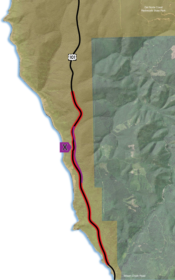
X
End-to-End Re-Engineering
What is Alternative X?
Alternative X includes a large-scale subsurface drainage system and additional retaining structures to reduce impacts to the roadway due to landslide movement. The highway alignment would generally follow the current highway’s alignment with one travel lane in each direction and eight-foot shoulders.
Alternative X would include:
- Minor realignment retreat to the east at key locations;
- Drainage infrastructure to reduce landslide movement; and
- Steel-reinforced timber-lagged retaining walls.
Alternative X is the lowest cost build alternative, would have the smallest environmental footprint of all the alternatives studied to date, and would have the shortest construction duration. The anticipated time to construct Alternative X is approximately 3-5 years and the current estimated cost to construct it is $880 million (in year 2031 dollars).
On the map, the alternative is denoted with a letter. The red line indicates the current LCG alignment.
Please note the following:
- The lines on the map are approximate and do not indicate the exact placement of the alternative.
- Costs are estimated and include construction, materials disposal, and mitigation.