New Alts Page Test Draft
Choose an alternative below:
- ALL
- EA
- A1
- A2
- F
- L
- X
- C3
- C4
- C5
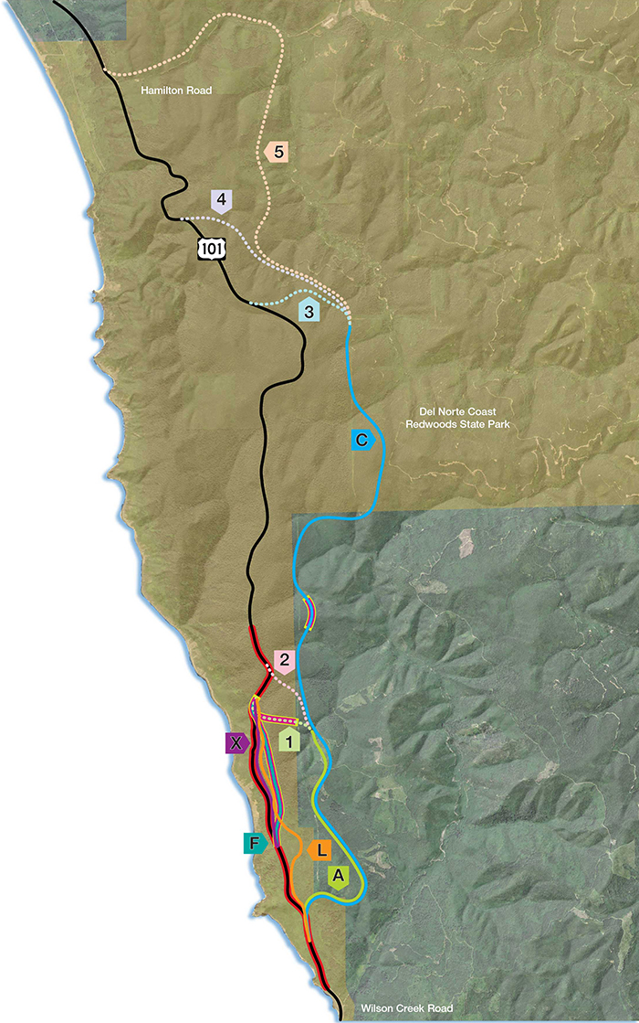
ALL
Last Chance Grade Alternatives for Further Study
The Last Chance Grade Feasibility Study identified a number of possible alternatives to the existing highway. Several alternatives have been excluded from further study; the remaining alternatives are now being further analyzed and refined in the Project Study Report.
Please note the following:
- The acreages of “Existing Habitat Type” are estimates based on overall analyses of habitat types in the area.
- Costs are estimated and include construction, materials disposal, and mitigation.
Use the buttons above to select an alternative and find out more information about each of them.
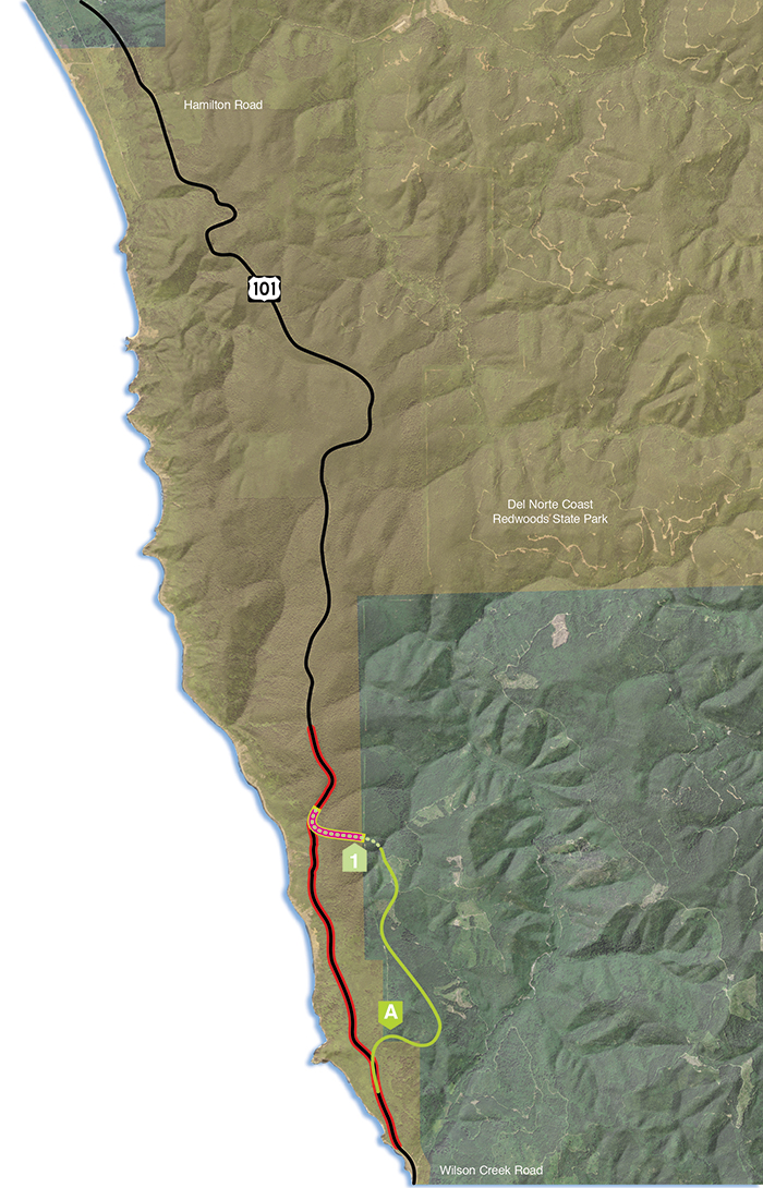
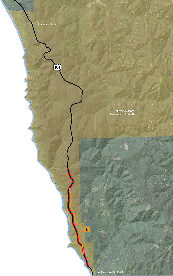
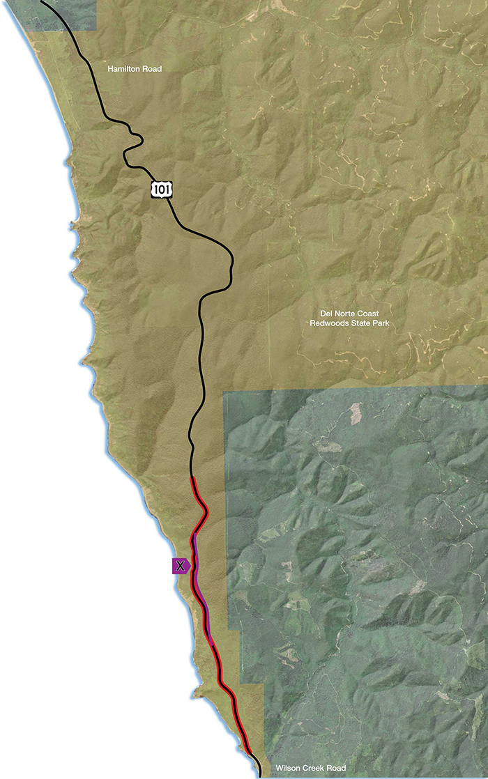
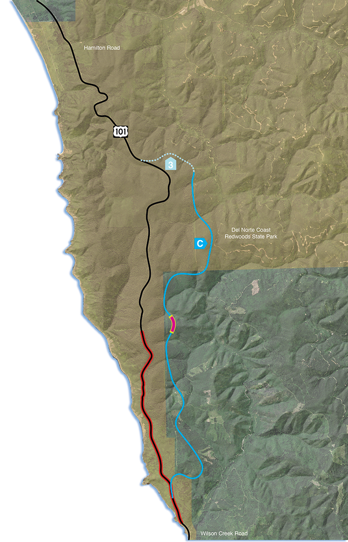
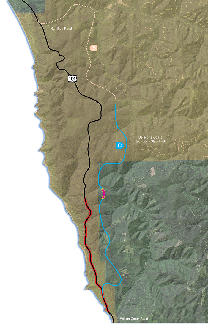
Each alternative is denoted with a letter, indicating one of the solid lines on the map; and a number, indicating one of the dotted lines.
On the maps, the red line indicates the current LCG alignment; pink segments outlined in yellow indicate the approximate position of tunnels.
Click here to see the alternatives that have been eliminated from further study.
The Project stakeholders and the project development team agreed in late 2018 to eliminate the three C alternatives from further study for the following reasons:
- The Expert Risk Assessment estimated that these alternatives have a high risk of geotechnical failure. The risk of building these alignments is higher than staying on the current alignment and making improvements as alternative X would do.
- The C alternatives have no unique environmental benefits.
- The C alternatives are high cost and have high environmental impacts.

EA
Maintain Existing Alignment
This alternative will have no planned construction; US 101 will continue on its existing alignment. Regular maintenance and operations will continue, with emergency restoration projects as needed. Current annual maintenance costs of $2 million with a projected cost of approximately $26 million by 2034. Engineering solutions, such as retaining walls, have not been able to provide long-term stability and will continue to be necessary to provide an adequate highway facility. As the landslide moves slowly, the road will require costly repairs and maintenance with potential environmental impacts including old-growth redwood impacts associated with minor retreats to keep the roadway open. A future slide might occur that is deep enough and large enough that it could result in a major failure of the roadway and complete closure of the roadway for an unknown period of time. A major failure would have economic impacts and require a significant detour as outlined in the Economic Impact Study. Some potential options closest to the existing alignment include a retreat upslope that could require taking more than 100 old-growth trees. For a more detailed explanation, please refer to page 15 of the Engineered Feasibility Study, available in the Document Library.
On the map, the red line indicates the current LCG alignment.
A1
Rudisill Road to LCG Tunnel
(Includes 2,425 foot tunnel)
Travel Time Added (minutes)
Added Time: 1.0 min
New Construction
Construction Length: 3.2 miles
Structures:
- Culverts > 36”: 9
- Tunnel: Yes
- Bridges: 1
Length Within Parks: 0.8 miles
Construction Footprint: 80 acres
Construction Schedule: 3 years
Watershed Crossings
Wilson Creek: 1
Mill Creek: 0
Construction Cost in 2016 $ (Millions)
$672M
Existing Habitat Type
Coastal scrub/grassland /spruce: 7 acres
Riparian: 1 acre
Clear cut: 13 acres
Young Redwood Forest: 57 acres
Mature Redwood Forest: 0 acres
Old Growth Redwood Forest: 1.5 acres
On the map, the alternative is denoted with a letter and a number, if the alternative has multiple segment options. The red line indicates the current LCG alignment and the pink area with yellow border indicates the position of the tunnel.
Please note the following:
- The lines on the map are approximate and do not indicate the exact placement of the alternative.
- The acreages of “Existing Habitat Type” are estimates based on overall analyses of habitat types in the area.
- Costs are estimated and include construction, materials disposal, and mitigation.

A2
Rudisill Road to Damnation Trailhead
Travel Time Added (minutes)
Added Time: 0.8 min
New Construction
Construction Length: 3.2 miles
Structures:
- Culverts > 36”: 10
- Tunnel: No
- Bridges: 2
Length Within Parks: 0.6 miles
Construction Footprint: 85 acres
Construction Schedule: 2 years
Watershed Crossings
Wilson Creek: 2
Mill Creek: 0
Construction Cost in 2016 $ (Millions)
$240M
Existing Habitat Type
Coastal scrub/grassland /spruce: 7 acres
Riparian: 1 acre
Clear cut: 13 acres
Young Redwood Forest: 61 acres
Mature Redwood Forest: 0 acres
Old Growth Redwood Forest: 3 acres
On the map, the alternative is denoted with a letter and a number, if the alternative has multiple segment options. The red line indicates the current LCG alignment.
Please note the following:
- The lines on the map are approximate and do not indicate the exact placement of the alternative.
- The acreages of “Existing Habitat Type” are estimates based on overall analyses of habitat types in the area.
- Costs are estimated and include construction, materials disposal, and mitigation.

F
LCG Tunnel - Full Tunnel Parallel to Existing Alignment
(5,600 foot tunnel)
Travel Time Added (minutes)
Added Time: 1.0 min
New Construction
Construction Length: 1.3 miles
Structures:
- Culverts > 36”: N/A
- Tunnel: Yes
- Bridges: N/A
Length Within Parks: N/A miles
Construction Footprint: 4.5 acres
Construction Schedule: 6.5 years
Watershed Crossings
Wilson Creek: N/A
Mill Creek: N/A
Construction Cost in 2016 $ (Millions)
$1,062M
Existing Habitat Type
Coastal scrub/grassland /spruce: 2 acres
Riparian: 0 acres
Clear cut: 0 acres
Young Redwood Forest: 0 acres
Mature Redwood Forest: 1 acre
Old Growth Redwood Forest: 1.5 acres
On the map, the alternative is denoted with a letter and a number, if the alternative has multiple segment options. The red line indicates the current LCG alignment and the pink area with yellow border indicates the position of the tunnel.
Please note the following:
- The lines on the map are approximate and do not indicate the exact placement of the alternative.
- The acreages of “Existing Habitat Type” are estimates based on overall analyses of habitat types in the area.
- Costs are estimated and include construction, materials disposal, and mitigation.
L
Upslope Realignment
Travel Time Added (minutes)
Added Time: 2.2 min
New Construction
Construction Length: 1.3 miles
Structures:
- Walls > 1
- Tunnel: No
- Bridges: N/A
Length Within Parks: 2.2 miles
Construction Footprint: 47 acres
Construction Schedule: 3.5 years
Watershed Crossings
Wilson Creek: N/A
Mill Creek: N/A
Construction Cost in 2016 $ (Millions)
$220M
Existing Habitat Type
Coastal scrub/grassland /spruce: 28 acres
Riparian: 0 acres
Clear cut: 0 acres
Young Redwood Forest: 0 acres
Mature Redwood Forest: 18 acres
Old Growth Redwood Forest: 1 acre
On the map, the alternative is denoted with a letter and a number, if the alternative has multiple segment options. The red line indicates the current LCG alignment and the pink area with yellow border indicates the position of the tunnel.
Please note the following:
- The lines on the map are approximate and do not indicate the exact placement of the alternative.
- The acreages of “Existing Habitat Type” are estimates based on overall analyses of habitat types in the area.
- Costs are estimated and include construction, materials disposal, and mitigation.
X
On Alignment Improvements
Travel Time Added (minutes)
Added Time: 1.1 min
New Construction
Construction Length: 1.3 miles
Structures:
- Walls > 8
- Tunnel: No
- Bridges: N/A
Length Within Parks: 1.1 miles
Construction Footprint: 20 acres
Construction Schedule: 3.5 years
Watershed Crossings
Wilson Creek: N/A
Mill Creek: N/A
Construction Cost in 2016 $ (Millions)
$120M
Existing Habitat Type
Coastal scrub/grassland /spruce: 10 acres
Riparian: 0 acres
Clear cut: 0 acres
Young Redwood Forest: 0 acres
Mature Redwood Forest: 10 acres
Old Growth Redwood Forest: 0 acres
On the map, the alternative is denoted with a letter and a number, if the alternative has multiple segment options. The red line indicates the current LCG alignment and the pink area with yellow border indicates the position of the tunnel.
Please note the following:
- The lines on the map are approximate and do not indicate the exact placement of the alternative.
- The acreages of “Existing Habitat Type” are estimates based on overall analyses of habitat types in the area.
- Costs are estimated and include construction, materials disposal, and mitigation.
C3
Rudisill Road to South of Mill Creek Access
The Project stakeholders and the project development team agreed in late 2018 to eliminate the three C alternatives from further study for the following reasons:
- The Expert Risk Assessment estimated that these alternatives have a high risk of geotechnical failure. The risk of building these alignments is higher than staying on the current alignment and making improvements as alternative X would do.
- The C alternatives have no unique environmental benefits.
- The C alternatives are high cost and have high environmental impacts.
- Culverts > 36”: 19
- Tunnel: Yes
- Bridges: 4
- The lines on the map are approximate and do not indicate the exact placement of the alternative.
- The acreages of “Existing Habitat Type” are estimates based on overall analyses of habitat types in the area.
- Costs are estimated and include construction, materials disposal, and mitigation.
(Includes 1,680 foot tunnel)
Travel Time Added (minutes)
Added Time: 1.7 min
New Construction
Construction Length: 7.8 miles
Structures:
Length Within Parks: 3.2 miles
Construction Footprint: 245 acres
Construction Schedule: 3 years
Watershed Crossings
Wilson Creek: 6
Mill Creek: 3
Construction Cost in 2016 $ (Millions)
$798M
Existing Habitat Type
Coastal scrub/grassland /spruce: 7 acres
Riparian: 1 acre
Clear cut: 13 acres
Young Redwood Forest: 200 acres
Mature Redwood Forest: 23 acres
Old Growth Redwood Forest: 0 acres
On the map, the alternative is denoted with a letter and a number, if the alternative has multiple segment options. The red line indicates the current LCG alignment and the pink area with yellow border indicates the position of the tunnel.
Please note the following:

C4
Rudisill Road to North of Mill Creek Access
The Project stakeholders and the project development team agreed in late 2018 to eliminate the three C alternatives from further study for the following reasons:
- The Expert Risk Assessment estimated that these alternatives have a high risk of geotechnical failure. The risk of building these alignments is higher than staying on the current alignment and making improvements as alternative X would do.
- The C alternatives have no unique environmental benefits.
- The C alternatives are high cost and have high environmental impacts.
- Culverts > 36”: 14
- Tunnel: Yes
- Bridges: 5
- The lines on the map are approximate and do not indicate the exact placement of the alternative.
- The acreages of “Existing Habitat Type” are estimates based on overall analyses of habitat types in the area.
- Costs are estimated and include construction, materials disposal, and mitigation.
(Includes 1,680 foot tunnel)
Travel Time Added (minutes)
Added Time: 1.5 min
New Construction
Construction Length: 8.6 miles
Structures:
Length Within Parks: 4.0 miles
Construction Footprint: 265 acres
Construction Schedule: 4 years
Watershed Crossings
Wilson Creek: 6
Mill Creek: 4
Construction Cost in 2016 $ (Millions)
$848M
Existing Habitat Type
Coastal scrub/grassland /spruce: 7 acres
Riparian: 1 acre
Clear cut: 13 acres
Young Redwood Forest: 200 acres
Mature Redwood Forest: 43 acres
Old Growth Redwood Forest: 0 acres
On the map, the alternative is denoted with a letter and a number, if the alternative has multiple segment options. The red line indicates the current LCG alignment and the pink area with yellow border indicates the position of the tunnel.
Please note the following:
C5
Rudisill Road to Hamilton Road
The Project stakeholders and the project development team agreed in late 2018 to eliminate the three C alternatives from further study for the following reasons:
- The Expert Risk Assessment estimated that these alternatives have a high risk of geotechnical failure. The risk of building these alignments is higher than staying on the current alignment and making improvements as alternative X would do.
- The C alternatives have no unique environmental benefits.
- The C alternatives are high cost and have high environmental impacts.
- Culverts > 36”: 21
- Tunnel: Yes
- Bridges: 11
- The lines on the map are approximate and do not indicate the exact placement of the alternative.
- The acreages of “Existing Habitat Type” are estimates based on overall analyses of habitat types in the area.
- Costs are estimated and include construction, materials disposal, and mitigation.
(Includes 1,680 foot tunnel)
Travel Time Added (minutes)
Added Time: 2.6 min
New Construction
Construction Length: 11.7 miles
Structures:
Length Within Parks: 7.0 miles
Construction Footprint: 330 acres
Construction Schedule: 4 years
Watershed Crossings
Wilson Creek: 6
Mill Creek: 10
Construction Cost in 2016 $ (Millions)
$1,003M
Existing Habitat Type
Coastal scrub/grassland /spruce: 7 acres
Riparian: 1 acre
Clear cut: 13 acres
Young Redwood Forest: 216 acres
Mature Redwood Forest: 93 acres
Old Growth Redwood Forest: 0 acres
On the map, the alternative is denoted with a letter and a number, if the alternative has multiple segment options. The red line indicates the current LCG alignment and the pink area with yellow border indicates the position of the tunnel.
Please note the following: